
Welcome to Pyatt
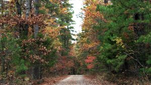
Pyatt, Arkansas, population 221 (2010 U.S. Census), is located in Marion County, Arkansas, amid the beautiful Ozark Mountains.
Crooked Creek, Bull Shoals Lake, and the Buffalo National River offers excellent smallmouth bass fishing. The White River, a world-famous trout stream, is also nearby. Bruno-Pyatt School, Home of the Patriots, is part of the Ozark Mountain School district.
History
Colonists in the area first called the settlement Stringtown, then later called it Clear Creek when the post office was established in 1855. The name of the settlement changed once again to Powell before it took on Pyatt. The city was incorporated in 1929 when the railroad entered the area.
Though small at just over one square mile, Pyatt has four structures in the National Register of Historic places, including the original old school house which was built in the early 1930s from hand-quarried rock. The first bank, the Bank of Pyatt, is still standing. It has been renovated but retains the original look and structure. The bank building is also made from hand-quarried stone.
Information sourced from the Encyclopedia of Arkansas.
Looking to relocate?
South Shore - Bull Shoals Lake, Arkansas - a great place to visit; a better place to live!
Location
Driving Distances from Pyatt
| City | Distance |
|---|---|
| Chicago | 599 miles NE |
| Dallas | 425 miles SW |
| Kansas City | 261 miles NW |
| Little Rock | 135 miles S |
| Memphis | 227 miles SE |
| St. Louis | 303 miles NE |
| Tulsa | 198 miles W |
| Wichita | 337 miles W |
Pyatt is located in north central Arkansas, about 30 miles south of the Arkansas-Missouri state line. It is accessed by a major non-Interstate east-west route, U.S. Highway 412/62. Less-traveled state highways 324 and 125 also lead into Pyatt. The nearest Interstate highways are Interstate 44 (100 miles north) and Interstate 40 (100 miles south). The town is situated on Crooked Creek, a popular fishing stream during wet weather.